Tag Archives: urban

Learning to Live with New Infrastructure Technology

The headline in The Atlantic, responding to an earlier article in the New York Times, asks the question, “Are we addicted to gadgets or indentured to work?”  (“Silicon Valley Says Step Away From the Device,” Matt Richtel, 7/23/2012, Business Day, New York Times.   “Are We Addicted to Gadgets or Indentured to Work?” Alexis Madrigal, 7/24/2012, The Atlantic. 

Matt Richtel, writing in The Times, reports that leaders at influential Silicon Valley companies are growing concerned about increasingly widespread addiction to gadgets.  Our attraction to smart phones, tablets, and on-line living, some say, reflects “primitive human longings to connect and interact” that threatens to take over our lives.  Next year’s edition of the authoritative Diagnostic and Statistical Manual of Mental Disorders, Richtel writes, is slated to include “Internet use disorder” in its appendix, indicating that the mental health profession thinks there may be a real problem but needs more research to understand it.

Responding in The Atlantic, Alexis Madrigal asserts the problem—for Americans, at least—is our slavish devotion to work.  We—or the upper middle class that reads the Times, at least—is working more and “having to stay more connected to work than ever before,” forced by employers (with the help of “our strange American political and cultural systems”) to be on the job 24/7. Citing both Mother Jones and McKinsey Quarterly as inspiration, Madrigal suggests that we need not simply to tear ourselves away from our electronic devices, but rather “organize politically and in civil society to change our collective relationship to work.,” adopting a more European perspective on our who controls our time.

Whether their myopia has an ideological or technological basis, both writers are overlooking the fundamental influence of our infrastructure.  In past decades motorized transport and telephone service dramatically reduced the influence of distance as an obstacle to economic and social interactions. The demands of maintaining international business networks and global supply chains shifted our ideas about “banker’s hours” and the sanctity of holidays and weekends.     Radio and television brought education and diversion, evolutionary emergence of “couch potatoes,” and threats to book and newspaper publishing.  These new infrastructures also supported and arguably accelerated dramatic expansion of the middle class and service sectors of the economy.  These changes went hand-in-hand with accelerating urbanization of our population and suburbanization of our cities.

As difficult as it may be to believe, digital wireless communication and the devices we carry to take advantage of this new infrastructure have become widespread in just about two decades.  The technology enables me and my colleagues—all of us somewhere well below the infamous top 2% of the income curve—to work from virtually anywhere and to shift working hours.  No longer must I take an entire day off to attend to medical appointments, to have my car repaired, or to attend my child’s school play.

I view this as new freedom rather than a grasping employer’s imposition. Many workers do not yet enjoy such freedom and, as in the past, some jobs are not suited to such changes of practice.

Recent statistics show an international trend of younger people being slower than preceding generations to get their driver’s permits.  Citing a study by the University of Michigan’s Transportation Research Institute, for example, MSNBC’s Paul Eisenstein reports that American teens are not rushing to get a driver’s license as soon as they become eligible, and that another study found similar trends in seven of 14 other industrialized countries.  (“American teens are waiting longer to drive,” Paul A. Eisenstein, 4/9/2012, MSNBC, Bottom Line)  In their own analysis, the Dayton Daily News found a 9 % drop in Ohio’s 16- and 17-year-old licensed drivers from 2006 to 2010, and a 4.7% decline in the number of Ohio 18-year-olds with licenses.

Analysts suggest the Internet, meaning particularly such new social media and communication applications as Facebook and text messaging, may be a key reason for the change.  Whatever the reasons, Eisenstein writes that auto company executives are worried that the trend may signal future declines in new-car demand.  Transit advocates are using the data to argue for higher government spending on urban public transportation systems.

How many hours we spend commuting, whether those hours can be used for anything other than steering and avoiding mishap, and whether the hours otherwise spent are counted as work or leisure are topics for another time.  Only consider for now the possibility that any purported addiction to gadgets and commitment work are simply short-term byproducts of learning to live with new infrastructure.

Living without electricity

Living without electricity for a while helps to focus the mind on how we rely on our infrastructure and our ability—or lack thereof—to make reasoned choices about that reliance.  Hurricane Irene swept up the mid-Atlantic coast on a weekend, likely reducing the storm’s impact on most businesses.  Forecasters did a nice job, giving plenty of warning of the approaching winds and rain, and many people seem to have been prepared for some inconvenience.  The hurricane’s actual path probably reduced the amount of damage at actually occurred, at least until the eye of the storm went inland and through New England to produce devastating floods.

Even so, disruption was extensive. Amid blowing winds and a torrential downpour, the power went out at my house at about 3 am Sunday morning.  A neighbor reported seeing the flashes of what we assumed to be the pole-mounted equipment blowing as downed branches and trees shorted out the overhead wires.  Baltimore Gas and Electric (BGE), the utility serving us, reported that some 750,000 of its 1.23 million customers in the region lost service. The public relations folks claim that crews have been brought in from as far away as Kentucky to help with repairs.

At home and still without power more than 72 hours later, I am able to use my laptop and communicate with the world thanks to cellular telephone service and 100 feet of extension cord plugged into my neighbor’s house across the street. His side of the block did not fail.  We plugged in the fridge, have a gas range and good supply of candles; I must admit that many others are suffering much more than we are at the moment.

At least three aspects of the situation nevertheless bother me.

First there is the customer service.  While BGE messages to customers claim they are working “around the clock,” local news reports that the repair crews shut down for the evening at 8 pm; the statistics reported for restorations of power show clearly there was no overnight progress. Four days since BGE claims to have started storm operations, more than 20 percent of customers who lost power are still in the dark.  Our local food market could not open and had to throw away thousands of dollars’ worth of spoiled goods.  The planned Monday opening for the city’s schools had to be pushed back to Wednesday.  I don’t think it is unreasonable to expect the utility to work around the clock to restore full service.  I don’t think it is unreasonable to expect that parts and materials should be available within a 2-day period from other parts of the continent to accommodate these foreseeable emergency demands.  Yet I cannot take my business elsewhere and there is no apparent way that failures of customer service will influence the company’s profitability or its executives’ income.

Second is the facility system.  Electricity is delivered to my city neighborhood and much of the region by overhead wires. Many storms far short of hurricane intensity cause frequent power interruptions. (To the BGE’s credit, my impression is such outages tend to be fixed within 4 to 6 hours, regardless of when and under what weather conditions they occur; this seems to me a reasonable standard.  Why are utilities and other infrastructure providers not required to make their performance statistics public, with standardized definitions and measurments?) While my definitely-leafy part of the city is less dense than many, I do not really understand why the poles have not been retired and the wires placed underground.  I know the initial cost would be high, but I not convinced it would not be more than offset by the avoidable out-of-pocket and inconvenience costs I pay for recurring outages and reductions in the utility’s maintenance expenses. I suspect that the idea of moving to underground installations throughout the city is made unattractive by utility accounting and regulatory systems (increased investment in fixed capital), not to mention the public-relations and political headaches of using cutting into city streets or securing private easements and connecting to each house and shop.  Nevertheless, I believe we should not have to consolidate to Manhattan-style densities to warrant the investment.

Finally, there is the thought of what the future may hold.  If costs for such new technologies as fuel cells, photovoltaic installations, and wind-powered generators continue to decline, as I expect they will, I think small customers located in less-dense areas will decide to cut their ties to the power grid.  Large corporate utilities will deal primarily with large consumers, whether they be businesses or multi-unit residential cooperatives and condominiums. A future in which a large fraction of households can meet their domestic energy demands from locally-supplied sun, breezes, and digested grass clippings and leaf collection is arguably more sustainable than what we now have, but it does imply maintaining what many people now call “sprawl.”

No Little Plans: The Dream of Abuja

Infrastructure provides an armature for urban development, and nowhere is this more apparent than in Abuja.  Nigeria’s dynamic and restless capital city, now the home of some 800,000 people and maybe more than a million, sprang from the bush barely just over three decades ago. As the nation settled down from a civil war and ten years of military rule, the young constitutional government resolved to build a new city in the middle of the country.  An international competition was held to select planners for the then-nameless capital. An American consortium won. In 1979, the master plan was published.  (Disclosure: I was a member of the core group of International Planning Associates professionals and subsequently Chief Planner for PRC (Planning Research Corporation) Nigeria.)

The new city—the name Abuja, originating as a 19th-Century emirate, was transferred from a small city now called Suleja, just to the north—was to be centrally positioned and ethnically neutral in a nation of diverse tribal identities, a showcase for national unity and modern African
urban development.  The underlying concepts were hardly revolutionary: Washington, DC, and many state capitals in the United States, for example, as well as Brasilia and St. Petersburg (Russia) had similar origins. In addition Lagos, the capital at the time, had grown beyond the capacity of its infrastructure; the city’s often chaotic services and gridlocked traffic threatened to choke the nation’s development.

Aso Rock would be the capital's backdrop

The desire for Abuja to provide a strong image and sense of place, representing Nigeria’s position as the most populous nation in Africa and a rising democratic force in the continent were decisive in the mater plan’s development.  As the capital, Abuja would have symbolic as well as political and economic importance.  The siting of major government buildings and the layout of the transportation networks were intended to take advantage of dramatic topography and provide the matrix for a centralized urban form easily served by transit.

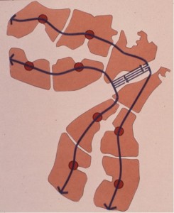
Transit spines and modular urban expansion areas

The plan’s curvilinear form was meant to serve the requirements for water supply and drainage by following the contour of the site in the shallow basin bounded by the Aso Rock and its surrounding hills. Parallel central transit spines and peripheral highways were planned to provide a framework for modular residential and commercial “mini-cities” that would be developed outward from the urban core as needed, each accommodating between 75,000 and 200,000 people and a full range of schools, healthcare, recreation, and other community services.  The program for residential land and housing sought to balance the government’s desire for high living standards for its citizens and the planners’ projections of incomes and affordability within an advancing but still relatively
less-developed economy.   With a government-set target population of 1.6 million by the year 2000 and 3 million ultimately, Abuja was planned be the largest free-standing new city ever built.  The federal government was to move from Lagos to Abuja by 1986.

It has been written that Daniel Burnham said, “Make no little plans. They have no magic to stir men’s blood and probably will not themselves be realized.”  Certainly Abuja’s master plan qualified as a grand scheme able to generate a certain excitement.  While government functions would be the principal foundation for the city’s economy, the plan represented substantial private-sector investment opportunity and, to use developers’ vernacular, the numbers worked. However, speaking at the American Association for the Advancement of Science annual meeting in Houston in 1978, I noted it would not be easy.  Threats to success could be foreseen in potential shortages of construction materials and labor, congestion of the poorly developed transportation network in Nigeria’s Middle Belt region, management challenges associated with such a large-scale undertaking, and the need for steadfast government support of the enterprise.

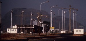
Early construction at Abuja, 1985

As it turned out, in the early stages of development some large buildings were constructed in advance of supporting infrastructure, so that government ministry workers in the early years labored under much-less-than-ideal conditions. The official shift of the capital to Abuja did
not occur until 1991.  The Nigerian press reports that electricity, sewer, and telecommunications systems continue to be problematic. Housing and land use have remained sources of continuous conflict over the years, with the master plan cited variously as a myth used to justify forcible evictions of lawful residents and a neglected guide for balanced growth.  (See, for example, a 2008 report from the Centre on Housing Rights and Evictions.)

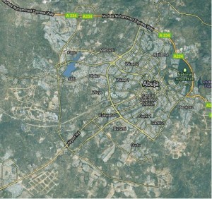
Satellite view of Abuja, 2010 (Google Earth)

Scottish poet Robert Burns wrote, “The best laid schemes o’ Mice an’ Men, Gang aft agley….” (To a Mouse, 1785)  The thought is a suitable caution to Burnham’s successors.

Flying Over Batam—Infrastructure of a New City and its Economic Development

I used Google Earth to visit Batam Island in Indonesia last week.  The trip was certainly easier than the nearly 24 hours of flying and layovers required when I made the trip from Washington two decades ago, and the view from above was an exciting indication of changes on the island.  But it was no substitute for being there in person.

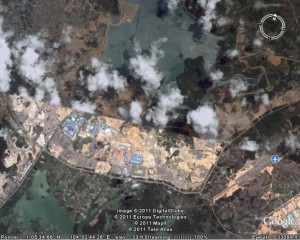
Batam Centre in 2011, as viewed with Google Earth.

Google Earth view of Batam Centre, 2011

I spent Christmas of 1983 with a band of like-minded planners and architects on Batam Island.  The rooms that we occupied were converted shipping containers, at one of the few hotels available.  The power went out on Christmas Eve, an almost daily occurrence, as we gathered with flashlights and candles in one room to open a few gifts thoughtfully provided by our colleagues back home.  With the tropical rain pouring down, we turned in early to be ready for the big day to come.

The story started a year earlier.  Planning Research Corporation was engaged by the Batam Industrial Development Authority (BIDA), then part of Indonesia’s Ministry of Technology, to prepare a master plan for Batam Centre.  (British spelling seemed to be the norm for English usage in Indonesia.)  We were teamed with an Indonesian firm, P. T. Atelier 6.  Prof. Dr. Eng. B. J. Habibie, Minister of Technology and Chairman of BIDA, was determined that Batam should be a free-trade enclave and focus for economic development as part of the Straits of Malacca (Singapore Straits) region.  (Habibie, who later became the president of Indonesia, continues to influence the island’s development.) The governments of Singapore and Indonesia had agreed to cooperate.

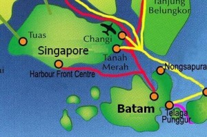
Batam, on the Malacca Strait (Singapore Strait)

Batam's location, near Singapore

Batam is located about 20 km southeast of Singapore, a short hydrofoil ride from that high-tech island nation.. Batam Centre was to be the administrative and commercial core of the island, a thoroughly modern enclave that would be a comfortable entry for foreign investors and an attraction for vacationers seeking a taste of Indonesia’s rich and colorful culture. As project manager and team leader, I was determined that the plan should be a practical roadmap and model for improved living standards in a growing economy as well as a resource for marketing a nation.

We conducted the usual economic analyses and demographic studies to project plausible population and income scenarios for the island and our emerging concepts of the new city’s role in the region.  We extracted organizing principles from lessons learned about traditional villages and urban form, the social structure of Indonesia’s communities and neighborhoods, and the layers of government established to provide infrastructure and social services.  We studied the topography, soils, hydrology, flora and fauna to understand the environmental opportunities and constraints that should shape development. 

We thought about the educational and training requirements to produce a workforce to be employed by the businesses that might be attracted to Batam.  We projected the demand for housing, schools and health care facilities, transportation, water, power, and waste management.  We prepared tables of numbers, maps, sketches, and models.  Batam Centre—an imagined place on the shores of Tering Bay, covered in mangrove and other tropical vegetation—began to assume for us all what I have come to call a “texture of credibility.”

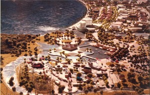
Illustrative model of the Batam Centre plan

Batam Centre, planned on the shore of Tering Bay

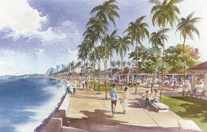
Rendering of view along Tering Bay in the Batam Centre master plan

"Dreaming in the daytime" on the waterfront in Batam Centre

We shipped our maps, drawings, models, and key members of our team to the island.  On Christmas Day we presented our 20-year plan to President Soeharto and his cabinet ministers.  When one of the senior officials told me the plan seemed “very Indonesian,” I was pleased.  Another told me we had helped them to “dream in the daytime.”

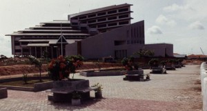
Batam visitors' center, 1991

Batam visitors' center, 1991

Scottish poet Robert Burns, wrote, “The best-laid schemes o’ mice an ‘men gang aft agley,” and so it was with our own scheme to continue working with BIDA to implement our Batam ideas.  By May of 1984 our work was finished, left for others to consider.  I was invited back in 1991 to review progress.  Major roads were in place and our plan was displayed in the visitors’ center BIDA had constructed on the site we had proposed. 

According to official statistics, Batam’s population today has grown about 50% from when we began our planning, to about 990,000.  There are now 66 hotels and beach resorts on the island, with 5,600 rooms available.  Foreign visitors to Batam average 100,000 monthly.  BIDA is responsible for development in the BARELANG region, the three islands of Batam, Rempang, and Galang, now joined by new highway bridges, one of Indonesia’s designated “national development engines.” 

Perhaps it was chance, but I prefer to believe that the physical, social, and economic framework our team laid out 20 years ago has served its purpose as an infrastructure for Batam Centre’s development.  If my satellite-enabled flyover is to be believed, the texture of credibility is becoming a reality.

What do you mean, “infrastructure?”

Looking at any city’s downtown skyline, one can easily forget that the tall buildings with their bright metal-and-glass surfaces rest on deep foundations.  Thousands of people gather together in these buildings each day, their labor justifying the buildings’ construction.  Roads, bridges, sewers, dams, and the like make it possible for these people to congregate and sustain themselves while they work and play; these various works themselves are the product of thousands of people.  Buried deeper still are the history and culture that give the city an essential character and make its skyline symbolic for those who know something of it.

 Infrastructure is a relatively new word. Historian Josef Konvitz conjectures that the the term probably appeared in print first in France about 1875.  (The Urban Millennium: The City‑Building Process from the Early Middle Ages to the Present, 1985, Southern Illinois University Press) The Oxford English Dictionary cites the same date. (2nd edition, 1989)  This venerable source goes on to attribute the first appearance in English in 1927, in Chambers’s Journal, a popular 19th-century literature, science, and arts weekly.  Winston Churchill reportedly referred dismissively in a 1950 speech in the British House of Commons to “the usual jargon about the infrastructure of supra‑national authority.”

 A search in my local library (remember those book stacks?) suggests that Americans were slow to pick up the term.  The earliest Webster’s entry I found is the Third New International Dictionary (unabridged, 1981), and that lacked any etymology.  The definition was an “underlying foundation or basic framework (as of an organization or a system),” referring especially to installations required for military purposes. 

 The word is everywhere today, and has been adopted particularly by the information and telecommunications industries.  A Google search for “infrastructure” on the Web—in February, 2011— turns up 119 million results. To compare: “cities” yields 398 million, “taxes” 174 million, and “Webster’s dictionary” only about 8.3 million.

 “Infrastructure” and “cities” together produces only 43.7 million hits.  This smaller subset is closer to representing my interests here.  Using the word infrastructure in the context of cities and larger regions really began in the mid-1980s.    Publication of America in Ruins: Beyond the Public Works Pork Barrel (1981, by Pat Choate and Susan Walter) kicked off a decade of national debate about the economic and political importance infrastructure, but the word itself was not much used in the book.  Congressionally funded studies yielded Public Works Infrastructure: Policy Considerations for the 1980s.in 1983, Hard Choices in 1985, and both New Directions for the Nation’s Public Works and Fragile Foundations in 1988. 

 Whatever else they may have accomplished, these studies did succeed at least in raising public awareness of the word.  Fragile Foundations in particular introduced the idea of a “report card” rating America’s infrastructure performance, awarding grades as low as “D-” for our water supply, mass transit, hazardous-waste management, and other systems.  It was a masterful metaphor that sharply boosted the frequency of infrastructure’s appearances in the New York Times, Washington Post, and Los Angeles Times.

 Yet the word’s meaning was not at all clear.  Some people thought only roads and highways, others were all-inclusive.  Was it only public works or private-sector as well?  I worked as a consultant with a National Research Council study that approached “public works infrastructure” in rather broad terms and introducing a concept new to the debate, that infrastructure is not simply hardware.  In a footnote to the study report that I drafted, we asserted that infrastructure “…includes both specific functional modes—highways, streets, roads, and bridges; mass transit; airports and airways; water supply and water resources; wastewater management; solid-waste treatment and disposal; electric power generation and transmission; telecommunications; and hazardous waste management–and the combined system these modal elements comprise.  A comprehension of infrastructure spans not only these public works facilities, but also the operating procedures, management practices, and development policies that interact together with societal demand and the physical world to facilitate the transport of people and goods, provision of water for drinking and a variety of other uses, safe disposal of society’s waste products, provision of energy where it is needed, and transmission of information within and between communities.” (Infrastructure for the 21st Century: Framework for a Research Agenda, 1987)

In other words, the infrastructure that interests me provides services to society.  The concept includes software as well as hardware.   It cannot be understood except in the context of the communities it serves.  That is my scope.  That is where I am coming from.