Tag Archives: cities

Battling Aging Infrastructure, the Enemy Is Us

Awash in local media headlines about Baltimore’s recent major water-main and sewer failures—and the flooding, street closures and business disruptions the inevitably accompany such events—Maryland’s Senator Ben Cardin and the city’s Mayor Stephanie Rawlings-Blake jointly signed an editorial in the local newspaper calling for reinvestment in our failing water systems. (Baltimore Sun, “Commentary”, 7/31/2012, p. 15)  The need, they wrote, is national.  They did not elaborate, but spectacular failures in other cities—Chicago in December 2011; suburban Atlanta and Washington, DC, in May 2012; and Kansas City in July, to give a few recent examples—offer persuasive support.

That these officials would go on record together in the cause of at least a portion of our nation’s infrastructure is certainly admirable.  However, the scope of their concern is too limited.  The problems of age, obsolescence, and catastrophic failure are not confined to water and sewer systems.  Across the nation bridge closures, natural-gas leaks, potholes, power outages, and erratic data connections have become painfully frequent.

It is also disappointing, albeit understandable, that the senator and mayor failed to acknowledge that we—a profligate citizenry and our elected leaders—are largely to blame for decades of deferred maintenance and failures to upgrade to new technology that have left our infrastructure in many places decrepit.

Parents generally understand that leaving their children a dilapidate house or car is not a great gift, but the typical taxpayer has little knowledge and less redress when a government executive or legislator chooses to satisfy vocal current interests at the expense of silent infrastructure. All residents and businesses suffer from this failure of fiduciary responsibility and leadership. We have systematically squandered a legacy built through the hard work of preceding generations.

Fool me once, so the saying goes, shame on you; fool me twice, shame on me.  If the time has come to reinvest, as Senator Cardin and Mayor Rawlings-Blake wrote, then as voters and taxpayers we should insist on a new deal: First, we should require that adequate funds are dedicated to infrastructure maintenance and upgrading so that decades hence our grandchildren are not confronted with the same crisis we now face.  Second, we should insist that our infrastructure is designed, constructed, and managed to provide reliable service and to be quickly repaired when failures occur.  Finally, we should rebuild with an eye on the future by incorporating smart information technology throughout the system. The people responsible for the infrastructure itself know how to do these things, but it will take leadership from elected officials to get them done.  Calling for reinvestment is only a small first step.

(An edited version of this post was published in the Baltimore Sun web edition in August 2012.)

Addendum on Abuja: Estimating costs

Estimating costs for a construction project many years in the future is always very uncertain.  When the project is very large, complex, and likely to require years to complete, the uncertainty will be even greater. When the project is located in an area where access is difficult; supplies of materials, equipment, and skilled labor may not be adequate to ensure steady progress; and the ability of the project’s owner to maintain long-term financial and managerial commitment is unclear, uncertainties increase further.

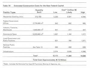
We therefore developed only a very approximate estimate of the cost for implementing the Abuja master plan at its initial, conceptual stage. Our first report, presented in December 1977 to the Federal Capital Development Authority, included this estimate (Table 14 of that report, shown below).  We envisioned Abuja at that time as a home for approximately 1.6 million people, occupying an urbanized area (including all the parks, roadways, and other infrastructure) of nearly 25,000 hectares.

Source: International Planning Associates, 1977. A New Federal Capital for Nigeria: Report No. 1, Concept Plan.


No Little Plans: The Dream of Abuja

Infrastructure provides an armature for urban development, and nowhere is this more apparent than in Abuja.  Nigeria’s dynamic and restless capital city, now the home of some 800,000 people and maybe more than a million, sprang from the bush barely just over three decades ago. As the nation settled down from a civil war and ten years of military rule, the young constitutional government resolved to build a new city in the middle of the country.  An international competition was held to select planners for the then-nameless capital. An American consortium won. In 1979, the master plan was published.  (Disclosure: I was a member of the core group of International Planning Associates professionals and subsequently Chief Planner for PRC (Planning Research Corporation) Nigeria.)

The new city—the name Abuja, originating as a 19th-Century emirate, was transferred from a small city now called Suleja, just to the north—was to be centrally positioned and ethnically neutral in a nation of diverse tribal identities, a showcase for national unity and modern African
urban development.  The underlying concepts were hardly revolutionary: Washington, DC, and many state capitals in the United States, for example, as well as Brasilia and St. Petersburg (Russia) had similar origins. In addition Lagos, the capital at the time, had grown beyond the capacity of its infrastructure; the city’s often chaotic services and gridlocked traffic threatened to choke the nation’s development.

Aso Rock would be the capital's backdrop

The desire for Abuja to provide a strong image and sense of place, representing Nigeria’s position as the most populous nation in Africa and a rising democratic force in the continent were decisive in the mater plan’s development.  As the capital, Abuja would have symbolic as well as political and economic importance.  The siting of major government buildings and the layout of the transportation networks were intended to take advantage of dramatic topography and provide the matrix for a centralized urban form easily served by transit.

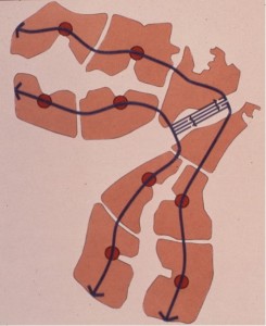
Transit spines and modular urban expansion areas

The plan’s curvilinear form was meant to serve the requirements for water supply and drainage by following the contour of the site in the shallow basin bounded by the Aso Rock and its surrounding hills. Parallel central transit spines and peripheral highways were planned to provide a framework for modular residential and commercial “mini-cities” that would be developed outward from the urban core as needed, each accommodating between 75,000 and 200,000 people and a full range of schools, healthcare, recreation, and other community services.  The program for residential land and housing sought to balance the government’s desire for high living standards for its citizens and the planners’ projections of incomes and affordability within an advancing but still relatively
less-developed economy.   With a government-set target population of 1.6 million by the year 2000 and 3 million ultimately, Abuja was planned be the largest free-standing new city ever built.  The federal government was to move from Lagos to Abuja by 1986.

It has been written that Daniel Burnham said, “Make no little plans. They have no magic to stir men’s blood and probably will not themselves be realized.”  Certainly Abuja’s master plan qualified as a grand scheme able to generate a certain excitement.  While government functions would be the principal foundation for the city’s economy, the plan represented substantial private-sector investment opportunity and, to use developers’ vernacular, the numbers worked. However, speaking at the American Association for the Advancement of Science annual meeting in Houston in 1978, I noted it would not be easy.  Threats to success could be foreseen in potential shortages of construction materials and labor, congestion of the poorly developed transportation network in Nigeria’s Middle Belt region, management challenges associated with such a large-scale undertaking, and the need for steadfast government support of the enterprise.

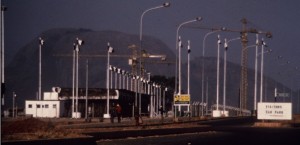
Early construction at Abuja, 1985

As it turned out, in the early stages of development some large buildings were constructed in advance of supporting infrastructure, so that government ministry workers in the early years labored under much-less-than-ideal conditions. The official shift of the capital to Abuja did
not occur until 1991.  The Nigerian press reports that electricity, sewer, and telecommunications systems continue to be problematic. Housing and land use have remained sources of continuous conflict over the years, with the master plan cited variously as a myth used to justify forcible evictions of lawful residents and a neglected guide for balanced growth.  (See, for example, a 2008 report from the Centre on Housing Rights and Evictions.)

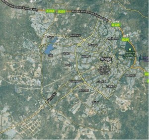
Satellite view of Abuja, 2010 (Google Earth)

Scottish poet Robert Burns wrote, “The best laid schemes o’ Mice an’ Men, Gang aft agley….” (To a Mouse, 1785)  The thought is a suitable caution to Burnham’s successors.

Flying Over Batam—Infrastructure of a New City and its Economic Development

I used Google Earth to visit Batam Island in Indonesia last week.  The trip was certainly easier than the nearly 24 hours of flying and layovers required when I made the trip from Washington two decades ago, and the view from above was an exciting indication of changes on the island.  But it was no substitute for being there in person.

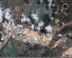
Batam Centre in 2011, as viewed with Google Earth.

Google Earth view of Batam Centre, 2011

I spent Christmas of 1983 with a band of like-minded planners and architects on Batam Island.  The rooms that we occupied were converted shipping containers, at one of the few hotels available.  The power went out on Christmas Eve, an almost daily occurrence, as we gathered with flashlights and candles in one room to open a few gifts thoughtfully provided by our colleagues back home.  With the tropical rain pouring down, we turned in early to be ready for the big day to come.

The story started a year earlier.  Planning Research Corporation was engaged by the Batam Industrial Development Authority (BIDA), then part of Indonesia’s Ministry of Technology, to prepare a master plan for Batam Centre.  (British spelling seemed to be the norm for English usage in Indonesia.)  We were teamed with an Indonesian firm, P. T. Atelier 6.  Prof. Dr. Eng. B. J. Habibie, Minister of Technology and Chairman of BIDA, was determined that Batam should be a free-trade enclave and focus for economic development as part of the Straits of Malacca (Singapore Straits) region.  (Habibie, who later became the president of Indonesia, continues to influence the island’s development.) The governments of Singapore and Indonesia had agreed to cooperate.

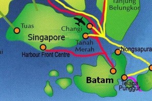
Batam, on the Malacca Strait (Singapore Strait)

Batam's location, near Singapore

Batam is located about 20 km southeast of Singapore, a short hydrofoil ride from that high-tech island nation.. Batam Centre was to be the administrative and commercial core of the island, a thoroughly modern enclave that would be a comfortable entry for foreign investors and an attraction for vacationers seeking a taste of Indonesia’s rich and colorful culture. As project manager and team leader, I was determined that the plan should be a practical roadmap and model for improved living standards in a growing economy as well as a resource for marketing a nation.

We conducted the usual economic analyses and demographic studies to project plausible population and income scenarios for the island and our emerging concepts of the new city’s role in the region.  We extracted organizing principles from lessons learned about traditional villages and urban form, the social structure of Indonesia’s communities and neighborhoods, and the layers of government established to provide infrastructure and social services.  We studied the topography, soils, hydrology, flora and fauna to understand the environmental opportunities and constraints that should shape development. 

We thought about the educational and training requirements to produce a workforce to be employed by the businesses that might be attracted to Batam.  We projected the demand for housing, schools and health care facilities, transportation, water, power, and waste management.  We prepared tables of numbers, maps, sketches, and models.  Batam Centre—an imagined place on the shores of Tering Bay, covered in mangrove and other tropical vegetation—began to assume for us all what I have come to call a “texture of credibility.”

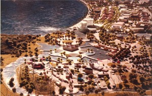
Illustrative model of the Batam Centre plan

Batam Centre, planned on the shore of Tering Bay

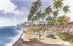
Rendering of view along Tering Bay in the Batam Centre master plan

"Dreaming in the daytime" on the waterfront in Batam Centre

We shipped our maps, drawings, models, and key members of our team to the island.  On Christmas Day we presented our 20-year plan to President Soeharto and his cabinet ministers.  When one of the senior officials told me the plan seemed “very Indonesian,” I was pleased.  Another told me we had helped them to “dream in the daytime.”

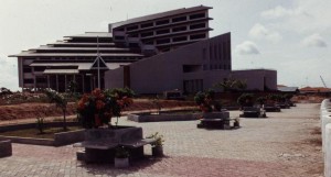
Batam visitors' center, 1991

Batam visitors' center, 1991

Scottish poet Robert Burns, wrote, “The best-laid schemes o’ mice an ‘men gang aft agley,” and so it was with our own scheme to continue working with BIDA to implement our Batam ideas.  By May of 1984 our work was finished, left for others to consider.  I was invited back in 1991 to review progress.  Major roads were in place and our plan was displayed in the visitors’ center BIDA had constructed on the site we had proposed. 

According to official statistics, Batam’s population today has grown about 50% from when we began our planning, to about 990,000.  There are now 66 hotels and beach resorts on the island, with 5,600 rooms available.  Foreign visitors to Batam average 100,000 monthly.  BIDA is responsible for development in the BARELANG region, the three islands of Batam, Rempang, and Galang, now joined by new highway bridges, one of Indonesia’s designated “national development engines.” 

Perhaps it was chance, but I prefer to believe that the physical, social, and economic framework our team laid out 20 years ago has served its purpose as an infrastructure for Batam Centre’s development.  If my satellite-enabled flyover is to be believed, the texture of credibility is becoming a reality.